 |
|
| Home | |
| Victor Hess | |
| Auger Project | |
| Coord.systems | |
| Terrestrial | |
| Galactic | |
| Celestial | |
| Space weather | |
| Unix Time | |
| Projects | |
| Ask me | |
| Contact | |
Celestial coordinate systems
|
The relative distances of stars cannot be perceived from Earth since they are far away. Thus, they appear to be located on a celestial sphere. The celestial sphere is an imaginary huge sphere concentric (having a common center) with the Earth (see Figure 1). The celestial equator is a projection of the earth's equator onto the celestial sphere. The north / south celestial poles are positioned directly above the north pole / below the south pole of the Earth. The following page describes two celestial coordinate systems, i.e. coordinate systems to parametrize the celestial sphere: The equatorial coordinate system und the horizon coordinate system |
|
The equatorial coordinate systemEquatorial coordinates are determined by the North celestial pole, the celestial equator and the vernal equinox point. The vernal equinox point is a point on the celestial equator. The sun appears to cross this point from south to north at the beginning of spring. Thus, to define the position of a star on the celestial sphere two coordinates are needed: Declination and right ascension define the position of a star on the celestial sphere. (see Figure 1) |
|
DeclinationThe Declination is the angle above or below the celestial equator. This angle is 0° at the celestial equator, +90° at the north celestial pole and -90° at the south celestial pole equivalent to latitude.Right AscensionEquivalent to longitude, the right ascension specifies the distance of a celestial object around the celestial equator. The zero reference point for the right ascension is the Vernal Equinox Point. The right ascension is 0h/24 h at this reference point and increases towards east. Since 360° correspond to 24 hours 15° right ascension are equal to 1 hour. |
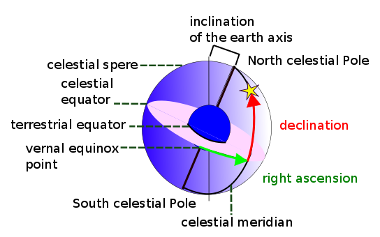
Figure 1: Equatorial coordinates
|
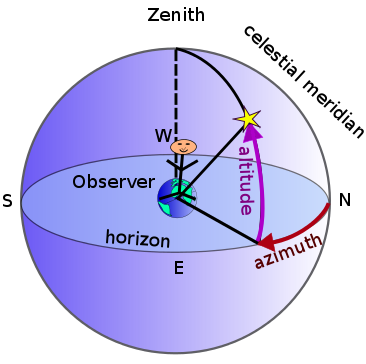
Figure 2:
left: Local coordinates right: Rotation of the Earth showing the change of view over time The red line symbolizes the horizontal plane |
|
The horizon coordinate systemThe horizon or "local" coordinate system describes the position of a star on the celestial sphere relative to the observer's celestial horizon and zenith. The coordinates of the star are its azimuth and altitude. The azimuth is an angle formed between a reference point (north point) and the position of the star projected on the horizon. The altitude is the angle between the direction of the star and the horizontal plane. You can calculate the local coordinates of the Sun depending on time and your position on Earth. |
|
Coordinate systems in the Auger experimentThe data from the detectors is first used to infer the arrival direction of a cosmic ray particle in the horizon "local" coordinate system. Computer programs convert the local coordinates to galactic and equatorial coordinates. |
|

Figure 3: Sextant
image from:http://en.wikipedia.org/wiki/File:Sekstant.jpg |
Celestial coordinate systems and seafaringCelestial coordinate systems were often used by seamen. The position on the globe could be determined by measuring the angle between a navigational star and the visible horizon (the celesital object's altitude) with a sextant. Nautical almanacs were utilized as a reference. These publications tabulate the coordinates of navigational celestial bodies at any given time during one year. Even though, this navigation system is now mostly replaced by satellite navigation, seaman still know how to use it to be able to navigate even in an emergency. |